PolygonLayer
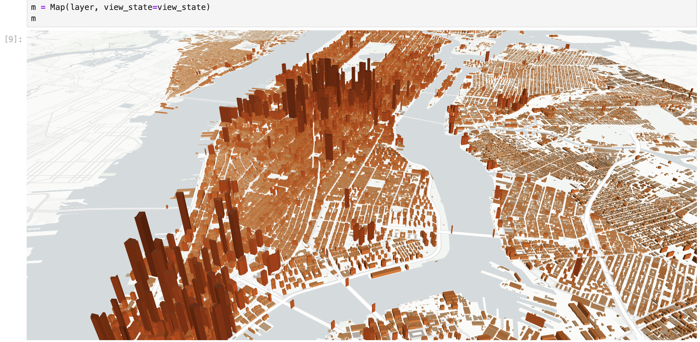
Screenshot from Overture Maps example
lonboard.PolygonLayer 
Bases: BaseArrowLayer
The PolygonLayer renders filled, stroked and/or extruded polygons.
Note
This layer is essentially a combination of a PathLayer
and a SolidPolygonLayer. This has some overhead
beyond a SolidPolygonLayer, so if you're looking for the maximum performance
with large data, you may want to use a SolidPolygonLayer directly.
Example:
From GeoPandas:
import geopandas as gpd
from lonboard import Map, PolygonLayer

# A GeoDataFrame with Polygon or MultiPolygon geometries
gdf = gpd.GeoDataFrame()
layer = PolygonLayer.from_geopandas(
    gdf,
    get_fill_color=[255, 0, 0],
    get_line_color=[0, 100, 100, 150],
)
m = Map(layer)
From an Arrow-compatible source like pyogrio or geoarrow-rust:
from geoarrow.rust.io import read_flatgeobuf
from lonboard import Map, PolygonLayer

# Example: A FlatGeobuf file with Polygon or MultiPolygon geometries
table = read_flatgeobuf("path/to/file.fgb")
layer = PolygonLayer(
    table,
    get_fill_color=[255, 0, 0],
    get_line_color=[0, 100, 100, 150],
)
m = Map(layer)
auto_highlight
class-attribute
instance-attribute
auto_highlight = Bool(default_value=False)
When true, the current object pointed to by the mouse pointer (when hovered over) is
highlighted with highlightColor.
Requires pickable to be True.
- Type:
bool - Default:
False
before_id
class-attribute
instance-attribute
before_id = Unicode(None, allow_none=True)
The identifier of a layer in the Maplibre basemap layer stack.
This deck.gl layer will be rendered just before the layer with the given identifier. You can find such an identifier by inspecting the basemap style JSON.
For example, in the Carto Positron style, if
you look at the raw JSON
data, each layer has
an "id" property. The first layer in the basemap stack has "id": "background".
So if you pass before_id="background", you won't see your deck.gl layer because it
will be rendered below all layers in the Maplibre basemap.
A common choice for Carto-based styles is to use before_id="watername_ocean" so
that your deck.gl layer is rendered above the core basemap elements but below all
text labels.
Info
This only has an effect when the map's basemap is a
MaplibreBasemap, and the map is rendering
in "interleaved" mode.
elevation_scale
class-attribute
instance-attribute
elevation_scale = Float(None, allow_none=True, min=0)
Elevation multiplier.
The final elevation is calculated by elevationScale * getElevation(d).
elevationScale is a handy property to scale all elevation without updating the
data.
- Type:
float, optional - Default:
1
extensions
class-attribute
instance-attribute
extensions = tag(sync=True, **(widget_serialization))
A list of layer extension objects to add additional features to a layer.
extruded
class-attribute
instance-attribute
extruded = Bool(None, allow_none=True)
Whether to extrude the polygons.
Based on the elevations provided by the getElevation accessor.
If set to false, all polygons will be flat, this generates less geometry and is
faster than simply returning 0 from getElevation.
- Type:
bool, optional - Default:
False
filled
class-attribute
instance-attribute
filled = Bool(None, allow_none=True)
Whether to draw a filled polygon (solid fill).
Note that only the area between the outer polygon and any holes will be filled.
- Type:
bool, optional - Default:
True
get_elevation
class-attribute
instance-attribute
get_elevation = FloatAccessor(None, allow_none=True)
The elevation to extrude each polygon with, in meters.
Only applies if extruded=True.
- Type: FloatAccessor, optional
- If a number is provided, it is used as the width for all polygons.
- If an array is provided, each value in the array will be used as the width for the polygon at the same row index.
- Default:
1000.
get_fill_color
class-attribute
instance-attribute
get_fill_color = ColorAccessor(None, allow_none=True)
The fill color of each polygon in the format of [r, g, b, [a]]. Each channel is a
number between 0-255 and a is 255 if not supplied.
- Type: ColorAccessor, optional
- If a single
listortupleis provided, it is used as the fill color for all polygons. - If a numpy or pyarrow array is provided, each value in the array will be used as the fill color for the polygon at the same row index.
- If a single
- Default:
[0, 0, 0, 255].
get_line_color
class-attribute
instance-attribute
get_line_color = ColorAccessor(None, allow_none=True)
The outline color of each polygon in the format of [r, g, b, [a]]. Each channel is
a number between 0-255 and a is 255 if not supplied.
Only applies if stroked=True.
- Type: ColorAccessor, optional
- If a single
listortupleis provided, it is used as the outline color for all polygons. - If a numpy or pyarrow array is provided, each value in the array will be used as the outline color for the polygon at the same row index.
- If a single
- Default:
[0, 0, 0, 255].
get_line_width
class-attribute
instance-attribute
get_line_width = FloatAccessor(None, allow_none=True)
The width of the outline of each polygon, in units specified by line_width_units
(default 'meters').
- Type: FloatAccessor, optional
- If a number is provided, it is used as the outline width for all polygons.
- If an array is provided, each value in the array will be used as the outline width for the polygon at the same row index.
- Default:
1.
highlight_color
class-attribute
instance-attribute
highlight_color = VariableLengthTuple(
    Int(), default_value=(0, 0, 128, 128), minlen=3, maxlen=4
)
RGBA color to blend with the highlighted object (the hovered over object if
auto_highlight=true). When the value is a 3 component (RGB) array, a default alpha
of 255 is applied.
- Type: List or Tuple of integers
- Default:
[0, 0, 128, 128]
line_joint_rounded
class-attribute
instance-attribute
line_joint_rounded = Bool(None, allow_none=True)
Type of joint. If true, draw round joints. Otherwise draw miter joints.
- Type:
bool, optional - Default:
False
line_miter_limit
class-attribute
instance-attribute
line_miter_limit = Float(None, allow_none=True, min=0)
The maximum extent of a joint in ratio to the stroke width.
Only works if line_joint_rounded is false.
- Type:
float, optional - Default:
4
line_width_max_pixels
class-attribute
instance-attribute
line_width_max_pixels = Float(None, allow_none=True, min=0)
The maximum outline width in pixels. This can be used to prevent the outline from getting too big when zoomed in.
- Type:
float, optional - Default:
None
line_width_min_pixels
class-attribute
instance-attribute
line_width_min_pixels = Float(None, allow_none=True, min=0)
The minimum outline width in pixels. This can be used to prevent the outline from getting too small when zoomed out.
- Type:
float, optional - Default:
0
line_width_scale
class-attribute
instance-attribute
line_width_scale = Float(None, allow_none=True, min=0)
The outline width multiplier that multiplied to all outlines of Polygon and
MultiPolygon features if the stroked attribute is true.
- Type:
float, optional - Default:
1
line_width_units
class-attribute
instance-attribute
line_width_units = Unicode(None, allow_none=True)
The units of the outline width, one of 'meters', 'common', and 'pixels'. See
unit
system.
- Type:
str, optional - Default:
'meters'
opacity
class-attribute
instance-attribute
opacity = Float(1, min=0, max=1)
The opacity of the layer.
- Type:
float. Must range between 0 and 1. - Default:
1
pickable
class-attribute
instance-attribute
pickable = Bool(default_value=True)
Whether the layer responds to mouse pointer picking events.
This must be set to True for tooltips and other interactive elements to be
available. This can also be used to only allow picking on specific layers within a
map instance.
Note that picking has some performance overhead in rendering. To get the absolute
best rendering performance with large data (at the cost of removing interactivity),
set this to False.
- Type:
bool - Default:
True
selected_index
class-attribute
instance-attribute
selected_index = Int(None, allow_none=True)
The positional index of the most-recently clicked on row of data.
You can use this to access the full row of data from a GeoDataFrame
gdf.iloc[layer.selected_index]
Setting a value here from Python will do nothing. This attribute only exists to be
updated from JavaScript on a map click. Note that pickable must be True (the
default) on this layer for the JavaScript onClick handler to work; if pickable
is set to False, selected_index will never update.
Note that you can use observe to call a function whenever a new value is received
from JavaScript. Refer
here
for an example.
stroked
class-attribute
instance-attribute
stroked = Bool(None, allow_none=True)
Whether to draw an outline around the polygon (solid fill).
Note that both the outer polygon as well the outlines of any holes will be drawn.
- Type:
bool, optional - Default:
True
table
class-attribute
instance-attribute
table = ArrowTableTrait(allowed_geometry_types={POLYGON, MULTIPOLYGON})
A GeoArrow table with a Polygon or MultiPolygon column.
This is the fastest way to plot data from an existing GeoArrow source, such as geoarrow-rust or geoarrow-pyarrow.
If you have a GeoPandas GeoDataFrame, use
from_geopandas instead.
visible
class-attribute
instance-attribute
visible = Bool(default_value=True)
Whether the layer is visible.
Under most circumstances, using the visible attribute to control the visibility of
layers is recommended over removing/adding the layer from the Map.layers list.
In particular, toggling the visible attribute will persist the layer on the
JavaScript side, while removing/adding the layer from the Map.layers list will
re-download and re-render from scratch.
- Type:
bool - Default:
True
wireframe
class-attribute
instance-attribute
wireframe = Bool(None, allow_none=True)
Whether to generate a line wireframe of the polygon. The outline will have "horizontal" lines closing the top and bottom polygons and a vertical line (a "strut") for each vertex on the polygon.
- Type:
bool, optional - Default:
False
Remarks:
- These lines are rendered with
GL.LINEand will thus always be 1 pixel wide. - Wireframe and solid extrusions are exclusive, you'll need to create two layers with the same data if you want a combined rendering effect.
__init__ 
__init__(
    table: ArrowStreamExportable,
    *,
    _rows_per_chunk: int | None = None,
    **kwargs: Unpack[PolygonLayerKwargs]
) -> None
Construct a Layer from a GeoArrow table.
This accepts Arrow data from any library implementing the Arrow PyCapsule Interface, including pyarrow, arro3, DuckDB, and others.
The geometry column will be reprojected to EPSG:4326 if it is not already in
that coordinate system.
Parameters:
-
table(ArrowStreamExportable) –An Arrow table or stream object from a library implementing the [Arrow PyCapsule Interface]. This object must contain a column with a geometry type that has the
geoarrowextension metadata.
Other Parameters:
-
kwargs(Unpack[BaseLayerKwargs]) –parameters passed on to
__init__
Returns:
-
None–A Layer with the initialized data.
from_duckdb
classmethod
from_duckdb(
    sql: str | DuckDBPyRelation,
    con: DuckDBPyConnection | None = None,
    *,
    crs: str | CRS | None = None,
    **kwargs: Unpack[PolygonLayerKwargs]
) -> Self
Construct a Layer from a duckdb-spatial query.
DuckDB Spatial does not currently expose coordinate reference system
information, so the user must ensure that data has been reprojected to
EPSG:4326 or pass in the existing CRS of the data in the crs keyword
parameter.
Parameters:
-
sql(str | DuckDBPyRelation) –The SQL input to visualize. This can either be a string containing a SQL query or the output of the duckdb
sqlfunction. -
con(DuckDBPyConnection | None, default:None) –The current DuckDB connection. This is required when passing a
strto thesqlparameter.
Other Parameters:
-
crs(str | CRS | None) –The CRS of the input data. This can either be a string passed to
pyproj.CRS.from_user_inputor apyproj.CRSobject. Defaults to None. -
kwargs(Unpack[BaseLayerKwargs]) –parameters passed on to
__init__
Returns:
-
Self–A Layer with the initialized data.
from_geopandas
classmethod
from_geopandas(
    gdf: GeoDataFrame,
    *,
    auto_downcast: bool = True,
    **kwargs: Unpack[PolygonLayerKwargs]
) -> Self
Construct a Layer from a geopandas GeoDataFrame.
The GeoDataFrame will be reprojected to EPSG:4326 if it is not already in that
coordinate system.
Parameters:
-
gdf(GeoDataFrame) –The GeoDataFrame to set on the layer.
Other Parameters:
-
auto_downcast(bool) –If
True, automatically downcast to smaller-size data types if possible without loss of precision. This calls pandas.DataFrame.convert_dtypes and pandas.to_numeric under the hood. -
kwargs(Unpack[BaseLayerKwargs]) –parameters passed on to
__init__
Returns:
-
Self–A Layer with the initialized data.