
In a country like Afghanistan with many remote and mountainous regions, winter snow can effectively shut down whole sections of the country. I originally designed the “Afghanistan Winter” tile set to show how Afghanistan’s winter landscape could affect logistics for international development operations. We have used these tiles more recently in a simulation to show what polling centers might have been affected if there was an early winter storm during the planned Afghanistan presidential election runoff that was originally scheduled to happen this week.
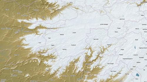
The amount of snow Afghanistan receives in the winter correlates very closely to elevation. Using Shuttle Radar Topography Mission elevation data and the open-source geospatial project GDAL, we were able to generate snow coverage very similar to actual satellite photography of the country after a snow storm.
The specific GDAL command I used was ‘gdaldem color-relief’, which takes a geotiff and colors pixels based on elevation data within the images. The colors are defined in a separate text file. These are the final colors I used for the snow:
`9000   255 255 255
2000   226 233 237
1600   186 168 115
0      143 140 87`
According to the FAO, the winter snowline in Afghanistan is 1800 meters, so I made sure that number landed in the middle of my gradient from rock to solid snow. I also set the snow color to a light blue-grey rather than solid white. When the hillshade layer is composited on top, this creates more realistic blue-tinted shadows.
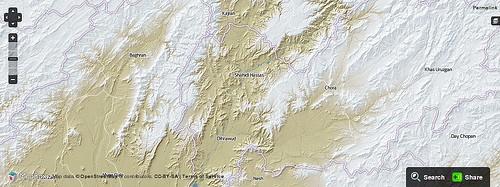
Here is an example of the tiles loaded into a site built on the Managing News platform. I am zoomed in to look at Northern Hilmand, Kandhar, and Western Uruzgan provinces.
If you are interested in other posts on Afghanistan topography and open source mapping tools, you might want to read “Summer in Kabul”, which I posted a few days ago, and “Creating Hillshades and Color Relief Maps Based on SRTM Data for Afghanistan and Pakistan” that Will White wrote this summer.
What we're doing.
Latest