

Next week in Montreal, the International Aid Transparency Initiative (IATI) will convene a Technical Advisory Group (TAG) meeting and bring together experts, developers, and users of IATI data to discuss ways to improve the standard and its use. As IATI considers improvements, we’ve been reflecting on our experiences and those of our partners working with the IATI data standard. The short story is that IATI is already making it easier to publish useful and usable aid data. However, challenges remain in achieving the level of coordination and interaction that many envisioned IATI would provide.
UNDP: dogfooding IATI data
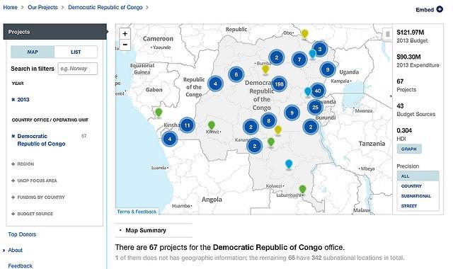
UNDP’s use of the IATI standard across its nearly 6,000 projects made it possible to easily open, publish, compare and aggregate UNDP data on open.undp.org. With the standard in place, geocoding and including location information in the data enabled UNDP this year to launch new subnational mapping visualizations, giving the ability to dive deeper into where UNDP is operating.
Sneak peek of the latest UI changes to open.undp.org
The UNDP transparency team has been on the leading edge of IATI utilization. Mark Cardwell will be in Montreal discussing their experience in the Implementing Agencies panel.
The standard isn’t standardly applied
While the IATI standard can be immensely useful in how an individual organization tracks and shares project data, comparing between organizations is still exceptionally difficult.
We’ve encountered real challenges in integrating IATI data from multiple sources.
-
Location comparisons. As we’ve been developing an interagency tool, location can be challenge to compare. Precise location is critical for cross-organization comparisons. Until more precise location information is available, use of IATI data will be limited to country level comparisons. Adoption of the location standard will greatly limit the ability to use IATI in a way that it could be. In addition, if two organizations uses different methods for geocoding or roll up their geocoded results to a certain level, visualizations on a map will be misleading.
-
Activity hierarchy and cross-organization comparisons. In a similar manner to location, comparisons across agencies can be a challenge. A simple script won’t combine each IATI file without significant custom work for each organization. For example, UNDP reports two levels of activities — projects and outputs — and gives financial, location, and other critical information only at the output level. UNOPS, in comparison, only reports top level activities — projects — including financial, location, and other information only at this top level. To make a comparison, we need to roll up UNDP activities into project level.
As the IATI Technical Advisory Group considers ways to extend the standard, it should also consider how to ensure more uniform application of the existing schema.
Let the future drive standards
Understandably, standards created by data producers tend to focus on the needs of publishers. They often under-appreciate the needs of the data customer and end users. One way to address this is to incorporate data consumpers and developers building end tools in all levels of the process of defining the standard. By involving data users and application developers, standards are more likely to be modern, progressive, and understand not only current uses but be flexible to adapt and enable future uses. Standards designed with developers will be more likely to include aspects, such as open and flexible formats, that will lead to the standard being widely used and adopted.
We are very excited about the potential of IATI to improve aid data and international development. We look forward to contributing to help it live up to its potential.
What we're doing.
Latest