TileMill 0.6.0 Released with Improved CSV Support and Usability Enhancements
- Estimated
- 3 min read
I’m pleased to announce another major release of the map design tool TileMill, which brings new support for CSV files, better desktop usability, and key stability fixes. You can download the latest version here.
Improved CSV support
The familiar file-based layer menu in TileMill now accepts tabular files (with the .csv, .tsv, or .txt extension) for direct rendering. CSV files can be read locally or via URL.

If you would like to test rendering the above CSV file, download it here.
Many programs can edit CSV files, but LibreOffice is great because it can edit tabular files directly without needing to export a copy. So a file like this can be opened in both LibreOffice for editing at the same time as it is being rendered in TileMill.

Simply save the document in LibreOffice (using “Keep Current Format”) and then re-save your TileMill project and the updates will be immediately visible in your map.
This feature opens an exciting door to rendering data directly from common sources like publicly published Google Docs spreadsheets and emerging data sharing sites like DataCouch.
This support is driven by the new ability for CSV format detection and parsing in Mapnik, the library used under the hood in TileMill for rendering. Because the CSV format is not strictly defined, Mapnik works to auto-detect various characteristics like the delimiter used to separate values (commas or tabs are currently supported), the type of newlines (unix, mac, or windows style), and the data types (integer, float, boolean, or string). Finally Mapnik detects fields containing coordinates using column headers, meaning any fields named x, lon, long, or containing the word longitude will be parsed as the x coordinate and fields named y, lat, or containing the word latitude will be parsed as the y coordinate. EPSG:4326/WGS84 is the assumed projection. If no coordinate fields can be detected, then the CSV is not considered valid. If you have CSV files with only addresses, then you should first geocode them.
Desktop usability enhancements
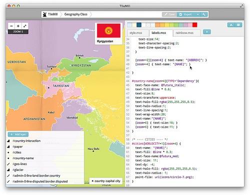
This release brings major new advances for desktop users of TileMill on Ubuntu and Mac OS X. The Mac OS X app now supports a clean one window interface, avoiding the need for a separate browser window. This feature leverages the latest support in Mac OS X for WebKit, the core technology behind Safari and Chrome. We’ve also focused on Mac OS X 10.7 Lion support and have added fullscreen support, which really lets you focus on map editing in a whole new way.

On Ubuntu, TileMill files are now kept in ~/Documents/MapBox by default, you can start TileMill from the 'Graphics' section in the Applications menu or launcher, and the process runs as your current logged in user - which will make permissions simpler for sharing data. But for a headless Ubuntu server installation, you can continue using TileMill as a server process using upstart. See the upgrade notes for more details.
Other features and fixes
Additionally, in this release users will find:
-
HTTPS support for remote datasources
-
New support for exporting SVG format maps in addition to PNG, JPEG, and PDF.
-
Several stability fixes for SQLite datasource (more are planned for the 0.6.1 release)
-
Better support for detecting ESRI-variant shapefile projections
-
Improved error feedback for layers that have unknown projections.
Download the latest TileMill release to check out these improvements, and as always, please post questions, feedback, and bugs to support.mapbox.com.
What we're doing.
Latest