
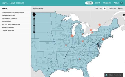
On Saturday we hosted a mapping and data event for the Great American Hackathon, organized by Sunlight Labs, where we designed and generated a map set showing the current congressional districts of the United States. Today we are publicly releasing it as a new tileset on MapBox.com. The tileset is a transparent overlay designed to be used with a base layer, such as the World-Light map that ships with Managing News. In short it allows people to overlay any sets of data, whether you want to see what districts are struggling with lots of flu cases like in the screenshot or just map general news or socio-economic data. Here is what the tiles look like on Managing News:
In addition to creating this tileset, the Hackathon allowed us to work on improving our OpenStreetMap Planet PostGIS database and better integrating it into our workflow. We ended up not using any OSM data in the final map, but it was still useful for previewing our design work in context. See Tom’s blog post from Monday for more information on how and why we are mirroring the OpenStreetMap database.
Through the Hackathon we were also able to share our map design process with other participants. There were some quick lessons on using QuantumGIS, manipulating data tables in OpenOffice, and designing maps with Cascadenik and Mapnik. Tom and Pius spent a while debugging a tough issue with Python on Snow Leopard with an obscure fix in compilation. Otherwise things went very smoothly. It was great to get some new hands in on the action and share the work we’ve been doing in recent months.
Thanks to Katie and Pius for coming out and joining us, and to Clay at Sunlight Labs for pushing the Hackathon and open data. The day went very well.
What we're doing.
Latest