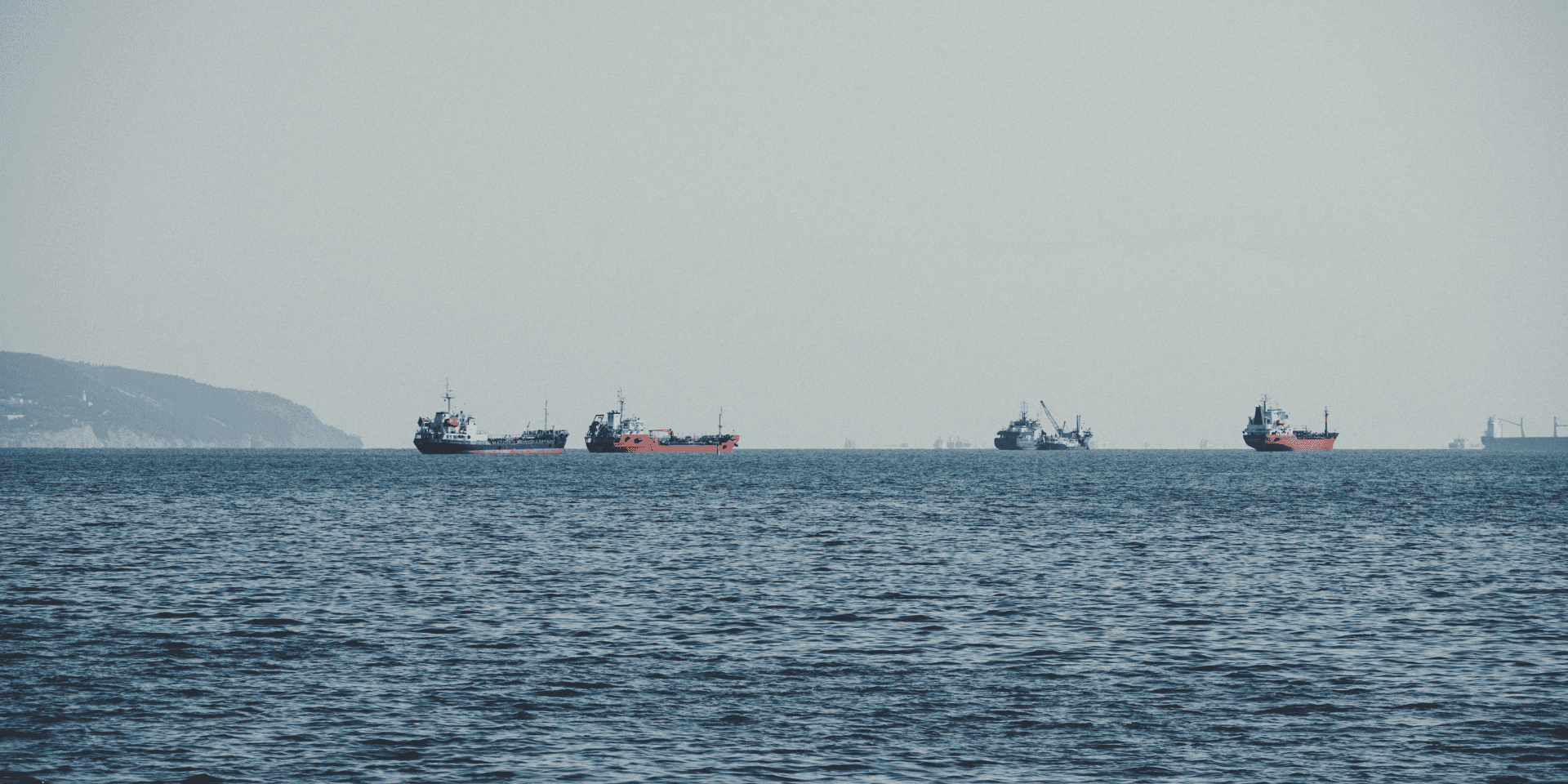
Discover how cutting edge satellite technology is revolutionizing our approach to uncovering hidden ocean oil pollutions.
Overview
Every day, shipping vessels worldwide accumulate oily wastewater, known as bilge water, from their operations. While regulations mandate the proper disposal of this water at ports, many vessels opt for the illegal route, dumping it directly into the sea to avoid costs and delays. The Cerulean platform leverages the Sentinel-1 satellite sensor to detect these oil slicks in real-time and hold the culprits accountable.
Challenge
The vastness of the oceans and the transient nature of oil slicks present significant challenges in detection. Not only do these slicks diffuse rapidly, often within 24 hours, but distinguishing illegal oil slicks from other similar-looking marine phenomena is a daunting task. Additionally, the decision between segmentation and object detection models complicates the process significantly when multiple events overlap in a single image.
Outcome
Utilizing the Sentinel-1 satellite sensor and advanced modeling techniques, the project successfully identified oil slicks on a global scale. The results, accessible through SkyTruth's Cerulean online mapping tool, showcase the detection system's effectiveness. This breakthrough not only aids in real-time identification but also serves as a deterrent for potential polluters, ensuring a safer and cleaner marine environment.
A Silent Threat
We all have heard about catastrophic oil spills from oil tankers like Prestige or Emerald that ran ashore. Spills from broken oil platforms like Deepwater Horizon are in everyone's memory, and these single events can pollute entire oceans.
What we haven’t heard of are the thousands of smaller oil slicks from vessels illegally dumping their oily wastewater into the sea. While these minor oil spills are less dramatic, they happen in large quantities, accounting for over 19% of global oil slicks, increasing ocean pollution.
All shipping vessels accumulate oily wastewater from their operations. Water used for cooling motors and cleaning equipment will accumulate concentrated toxic components. These waters are called bilge water, which should be disposed of at ports when the ships are docked there. The problem is that this does not always happen that way. Thousands of vessels illegally dump their bilge water into the sea. Despite regulation, the cost of disposing of bilge water due to delays and fees at port mean many ships continue to illegally dump their bilge water.
Development Seed has partnered with SkyTruth to help detect these oil slicks and associate them with shipping vessels’ GPS tracks. This will help identify polluters in real-time so that marine law enforcement agencies can be notified and take action.
Modeling
Fresh oil slicks have a clear pattern and can be detected reliably using remote sensing and computer vision. Oil slicks may come from fixed sources such as oil platforms, but vessels that navigate the seas are tougher to track due to their transient nature.
The Eye in the Sky
Sentinel-1 is the sensor platform used for this project, specifically the VV polarization for radar backscatter. Oil slicks change the backscatter behavior of microwave light over water. Oily ocean waters lead to smoother surfaces that scatter C-band radar away from the Sentinel-1 sensor. This reduces back-scatter, so oil slicks appear like darker patches over the water when visualizing back-scatter intensity. As usual, when working with Sentinel-1, it was of great advantage to not be affected by clouds.
Precision Sampling
For this project oil slicks were manually sampled from Sentinel-1 imagery to cover categories of interest: recent and old oil slicks from vessels, oil slicks from platforms, and natural seeps. Our Data Team developed a custom annotation workflow to annotate 500 Sentinel-1 scenes that represented the categories of interest, then handed the annotation process back to the SkyTruth team.
Overcoming Detection Hurdles
There are a few obstacles that have to be overcome to produce a reliable model.
Diffusion over time
In practice, detection is tricky because the slicks diffuse quickly, typically within 24 hours or less. This means oil slicks are only visible in the first hours after the bilge water is dumped. Over time, winds and currents in the water diffuse the slick, making it harder to detect.
False positives
Another difficulty is avoiding false positives. We need to differentiate illegal oil slicks from other phenomena similar to oil slicks. The following illustration shows a series of phenomena similar to oil slicks.
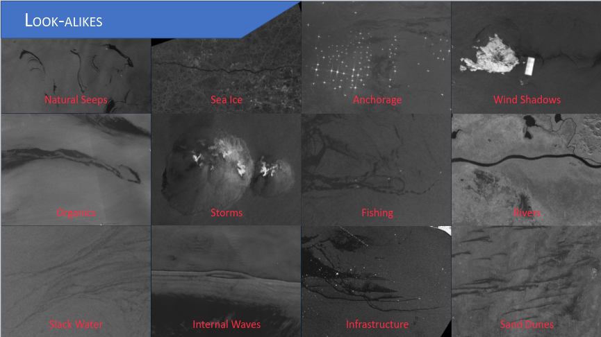
Image courtesy of SkyTruth
Choosing the right model
The model can be trained to identify oil slicks in various ways, and choosing the right one is crucial to generating high-quality insights. The most basic way to detect oil slicks is to train the model to draw a bounding box around each slick. This is called object detection. This model type is easier to train and enables some analysis, such as evaluating the increase or decrease in oil slicks over time. However, object detection does not allow us to know the exact shape of each oil slick. This is crucial to identifying the ships or infrastructure responsible for the slicks and evaluating the extent of the damage done to maritime ecosystems.
For these insights, we turn to segmentation, which assigns a class to each pixel in the image. There are multiple classes that a pixel can belong to - oil slicks from ships, oil slicks from infrastructure, or naturally occurring dark areas on the surface of the water (due to things like vegetation or bathymetry), and there may even be multiple overlapping slicks belonging to the same, or different categories. In this case, the model may incorrectly classify pixels from a single slick as belonging to different categories. To resolve this, we turn to a subset of segmentation models called instance segmentation, where we group all pixels corresponding to the same class instance (in this case, one single oil slick). This allows us to estimate the slick's surface area and identify likely culprits. This concept is illustrated below.
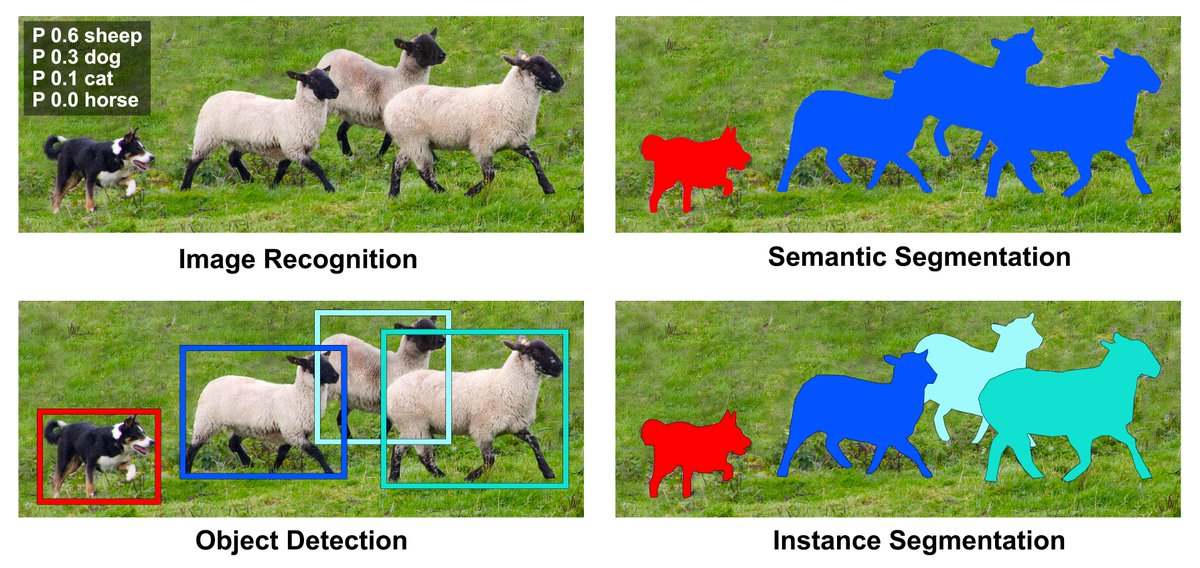
Illustrating conceptual differences between semantic and instance segmentation models.
Seamless Infrastructure
The project was deployed on Google Cloud Platform (GCP), SkyTruth’s preferred cloud. The Sentinel-1 data sits in AWS public buckets, so we built a cross-platform, relay-time monitoring infrastructure.
On the AWS side, a service notifies our GCP service when new scenes come online. Then, on the GCP side, the tasks are queued to run through multiple serverless cloud functions. No fixed infrastructure except the SQL database that hosts the results was set up. The following diagram describes the architecture.
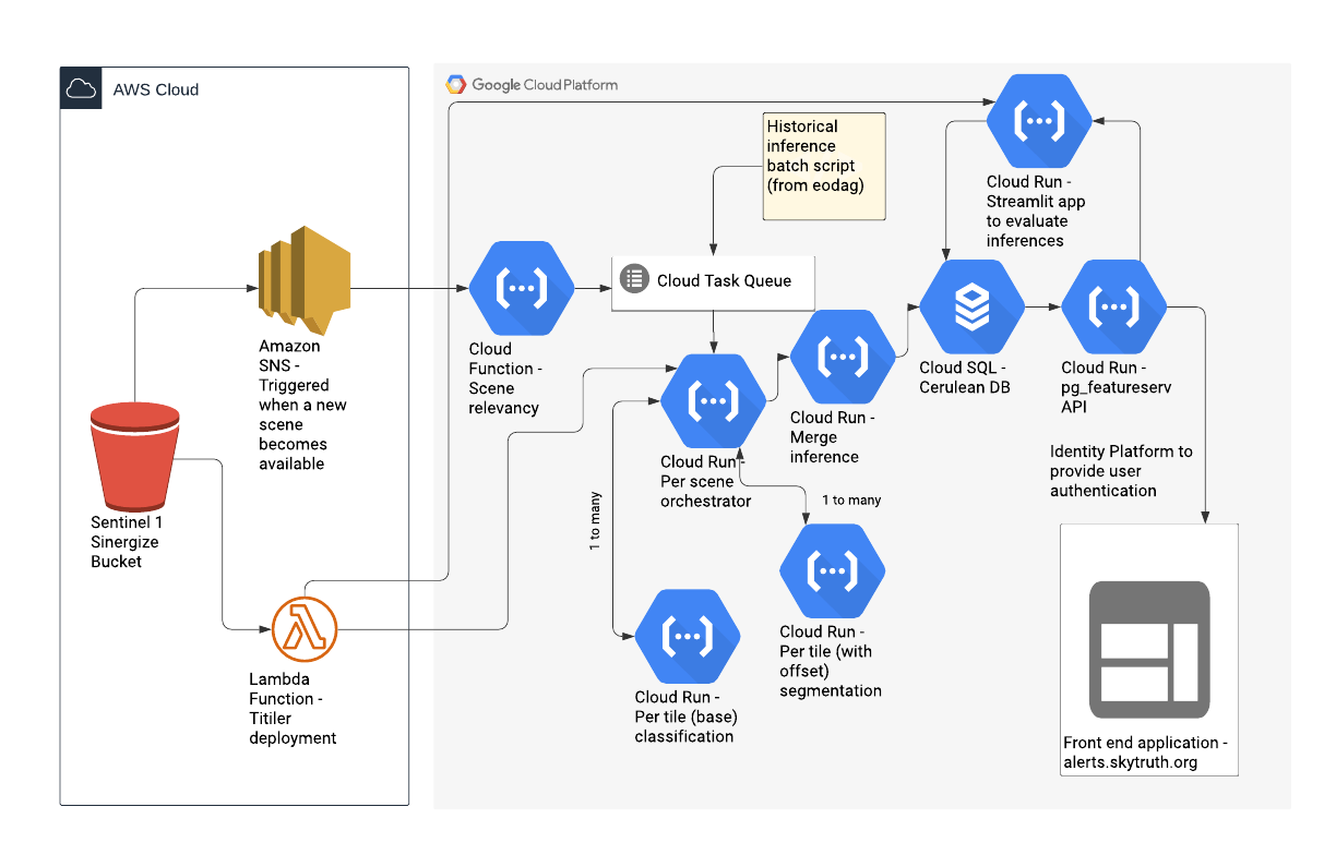
Architecture diagram for the Cerulean backend, across AWS and GCP
The Sentinel-1 images are quite large (order of 10k pixels width), so they need to be cut into smaller pieces for model inference. The image tiles were slightly overlapping to avoid edge effects when doing the inference on these smaller tiles.
The Cerulean front-end application displays the results of the detection algorithm, and allows users to filter detected oil slicks by machine confidence (how "sure" are we that the detected shape is indeed an oil slick) and oil slick surface area. Users can also search for oil slicks within specific economic exclusion zones or within specific marine protected areas
A Clearer Ocean
The detection tool has been used to successfully identify oils slicks globally. The results can be explored through the SkyTruth online interface: https://cerulean.skytruth.org/
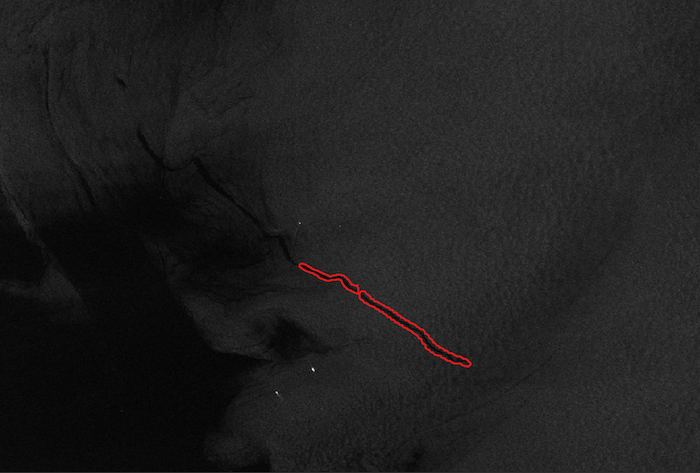
Identified oil slick segment.
While the oil slick detection model is constantly being improved and refined, the initial findings are significant, and have already seen impactful results. The Indonesia Economic Exclusion Zone was found to have as many oil slicks as the next five countries combined; in response, SkyTruth has set up a partnership with the Indonesian Ocean Justice Initiative (IOJI) to advance policy, enforcement and public awareness around oil spill events. In April 2023, SkyTruth partnered with Uplift UK and Oceana to investigate how oil released into UK waters impacts whales, dolphins, seals and other vulnerable marine life, creating an example of how advocates around the world can use Cerulean to hold ocean polluters accountable and inspire action for ocean conservation, climate actions, and biodiversity protection.
Have a challenging project that could use our help?
Let's connect
We'd love to hear from you.
