

A quarterly snapshot of our experimental tools and open-source work, driven by recurring questions about how to explore, visualize, and work with geospatial data more easily.

Groundwork is our quarterly snapshot of the experimental tools we’re building alongside partners and the open-source community. These projects are small by design — focused explorations of real problems we keep running into in our day-to-day work.
In this edition, we’re digging into a common thread across several efforts: making geospatial data easier to explore, query, and reason about. That shows up in different ways, from LLM agents that can interact with spatial data, to fast, local-first visualization of massive rasters in the browser, to new ways of structuring, searching, and sharing open datasets, from STAC catalogs to real-time transit feeds.
Some of these projects are already deployed and usable today. Others are rougher experiments meant to test ideas, learn quickly, and inform what comes next. Together, they offer a snapshot of what we’ve been focused on lately and where we think cloud-native geospatial tooling can be more practical and approachable.
Here’s what we’ve been working on:
1. GeoAssistant
Our GeoAI team met in person last December and built a sample project to demonstrate an end-to-end approach to interacting with geospatial data via LLM agents. This work grew out of a familiar challenge we keep seeing: people can ask good questions about places, but translating those questions into concrete spatial analysis often requires jumping between tools, formats, and mental models. We’re excited about this small repo because it builds on what we’ve learned from several LLM + geographic data projects and offers a small open-source example for others to get started.
Geo-Assistant is a LangGraph-based ReAct (Reasoning + Acting) agent that can answer questions and perform tasks related to location and geographic data using a set of tools. Streamlit is used for the frontend, and the backend is FastAPI-based.
Check out the documentation and repo here! Let us know if this helps you get started with interacting with geospatial data and LLMs, or if you have different architecture choices you’ve found useful.
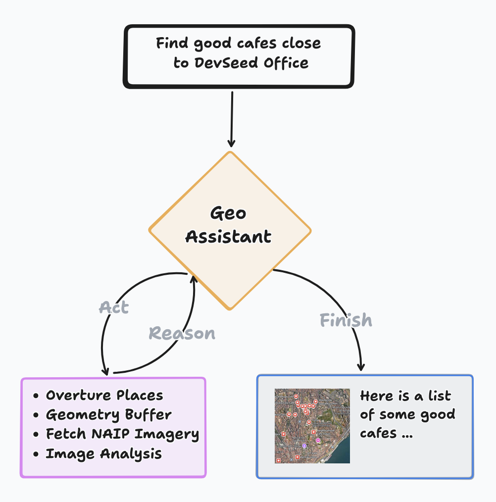
GeoAssistant.
2. stac-map + deck.gl-raster
We’ve combined two newer technologies to bring you snappy in-browser visualization of Cloud-Optimized GeoTIFFs. stac-map now includes deck.gl-raster layers for three-band GeoTIFFs, letting you browse any STAC catalog with publicly accessible assets and view those assets on the map, no tiling service required.
We’re working on deeper integration of deck.gl-raster into stac-map, especially around mosaicing. This will make it easier to explore large collections as continuous surfaces rather than isolated scenes, bringing us closer to fluid, map-first exploration of massive raster datasets in the browser. Stay tuned for more on deck.gl-raster and all the capabilities it will unlock, for stac-map and beyond!
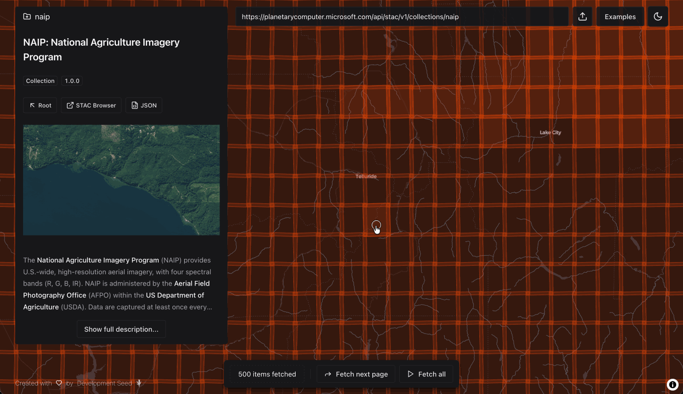
stac-map + deck.gl-raster brings easy COG visualization to your browser.
3. stac-react
We've released a major update to stac-react, our headless React library for querying STAC catalogs. This update reflects lessons learned from building real applications where fast feedback, responsive filtering, and predictable data fetching make a big difference to user experience.
The new version is built on TanStack Query, bringing improved caching, automatic background refetching, and optimistic updates. As a headless library, stac-react provides only the data fetching logic — no UI components, just hooks that integrate with your own design system. You can use your own TanStack Query instance or leverage our pre-configured setup. The updated documentation and examples are available on our GitHub.
stac‑react turns STAC queries into instant map & gallery results.
4. GTFS Realtime Data as GeoParquet
We’ve been working on a lightweight, open-source pipeline for collecting and sharing GTFS-Realtime transit data at scale. The project automates the ingestion of live vehicle location feeds and transforms them into GeoParquet, making large volumes of geospatial public transit data easy to store, query, and share in the cloud.
Like several other projects in this edition, this work explores what it looks like to make high-frequency geospatial data accessible without relying on always-on databases or proprietary systems. The result is a more accessible way for researchers, planners, and partners to explore high-resolution transit data without relying on complex databases or proprietary systems.
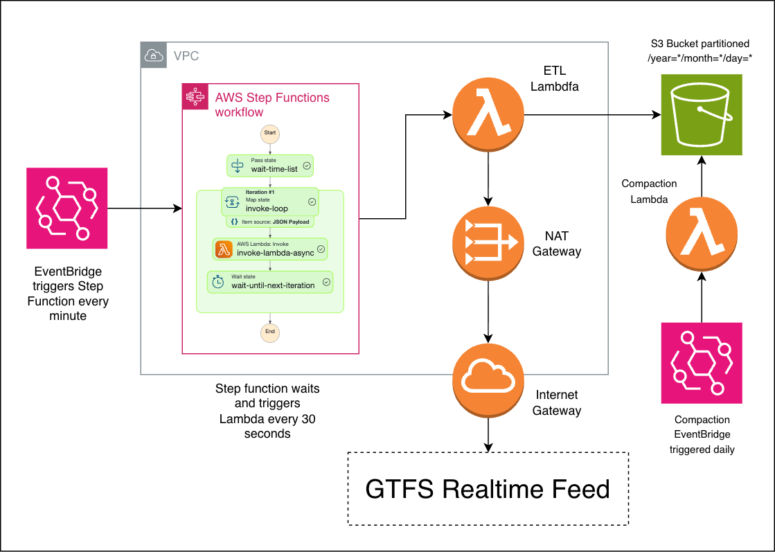
Serverless architecture for ingesting GTFS-Realtime feeds and publishing partitioned GeoParquet for scalable transit data analysis.
Join the Fun
From GeoAI agents that can reason over spatial data, to fast in-browser rendering of Cloud-Optimized GeoTIFFs, to cloud-native pipelines for sharing STAC and real-time transit data, these projects are all riffs on the same theme: making geospatial data more usable, performant, and human-friendly.
None of these are finished products. They’re experiments born out of real needs, half-formed ideas, and collaboration with the open-source community. If something here sparks your interest, we’d love to hear about it. Better yet, fork a repo, open an issue, or try one out in the wild. Get in touch if you have an idea or a sticky problem. We’re excited to see where these experiments lead.
We're thrilled to share our ideas with you!
Related content
More for you
What we're doing.
Latest