Label Maker has a number of new improvements which support reading from GeoTIFFs, creating better segmentation labels, and faster processing. We originally built Label Maker to quickly create machine learning-ready data for satellite imagery, and these new features will make it easier to incorporate your own satellite or drone data while creating high quality algorithms.
Release Highlights
Since the initial release, contributors have added a good mix of features, performance improvements, and bug fixes:
-
Added support for GeoTIFF reading. The first version required that your satellite imagery come from a Tile Map Service which meant relying on a third-party service or running your own server. Now whether you have a private local file or a remote Cloud Optimized GeoTIFF, you can create image and label chips on-demand. We also added a new option,
[imagery_offset](https://github.com/developmentseed/label-maker/pull/59), in tandem with this feature, to help align satellite images with OpenStreetMap data. -
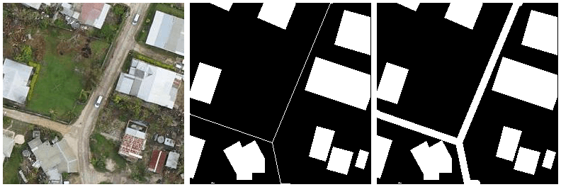
Added support for buffering
PointandLineStringgeometries. Now you can create more accurate segmentation labels from OpenStreetMap data without having to manually label images:
 Satellite Image from Tonga via OpenAerialMap; former segmentation label; new segmentation label with road buffering.
- New optional flag
--sparse. This allows you to reduce the total amount of saved background labels when working with very sparse features. Smaller datasets are faster to create, faster to load, and easier to upload to cloud instances for training.
The full list of updates is available in [CHANGES.txt](https://github.com/developmentseed/label-maker/blob/master/CHANGES.txt). Thanks to the contributors and Qiusheng Wu, the newest power user, for plenty of testing and feedback.
Tutorials
After release, Nana wrote two walkthroughs to help prepare data using Label Maker and then train a network on either AWS SageMaker or Tensorflow Object Detection API. The full tutorials and some other helpful utility code are available on the repo. File an issue or submit a PR if you’d like to see another tutorial for a different framework or use case.
Next Steps
The ability to quickly create training sets in geographically diverse regions is critical if we want to make sure the benefits of machine learning are not limited to the Western world. Toward this goal, there are a number of further improvements we’re planning to make Label Maker even more effective:
-
Downloading OpenStreetMap data in a more generic fashion
Please check out the repo if you’d like to help out or suggest other features. And let us know on Twitter if Label Maker has helped in one of your projects.
Featured image by Andrew Malone.
What we're doing.
Latest
