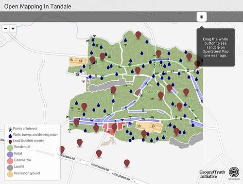
Over the last year, local residents of the informal settlement of Tandale within Dar Es Salaam made extensive additions to OpenStreetMap — essentially putting their community on the map. Our friends at the GroundTruth Initiative worked with community members and urban planning students at Ardhi University to create maps and build reporting resources. The project hoped to mirror the successes of Map Kibera by providing the tools to map important local issues stemming from rapid urban growth and lead to political recognition of these problems.
The Open Mapping in Tandale site showcases the extensive additions to OpenStreetMap made throughout the project, with a time slider showing the before and after of the data within OpenStreetMap.

This data behind the map layers is now available on OpenStreetMap and the community reports are powered by and accessible through Ushahidi.
The Open Mapping in Tandale site was built with the new MapBox JavaScript API, and the swipe layer functionality can be found in the example gallery. The map layers for land-use, water resources, and points of interest were taken from OpenStreetMap data from GeoFabrik and styled in Tilemill. The community reports were taken from the Ushahidi report platform with custom markers from markers.js.
The project was implemented by GroundTruth Initiative and done in partnership locally with Ardhi University, CCI, and Dar es Salaam City Council with support from the World Bank and Twaweza. Check out the progress on the Open Mapping in Tandale site.
What we're doing.
Latest