This afternoon InterAction and the World Bank are holding a half day workshop on GIS strategy and open source tools for humanitarian aid and international development. This workshop will be today (Thursday, May 3) from 1:00 to 6:00 pm at the World Bank here in Washington, DC.
This event comes on the heels of the InterAction Forum and the Humanitarian OpenStreetMap Team board meeting, which brought many open geo and development leaders to town. It is designed to be a conversation around the challenges facing many organizations around GIS. Proponents from NGOs, the World Bank, the OpenStreetMap community, and the private sector will share their experiences around mapping in development and aid in a series of panels and workshops.
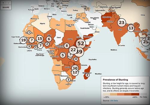
We will be there giving a workshop showing some of our recent map-based visualizations, talking about storytelling with maps, and diving into how to design and publish custom GIS and OpenStreetMap data with our open source map design studio TileMill. The workshop is geared towards a non-technical audience with our goal being to show what’s possible with existing open source tools.

Infant nutrition map we launched with the 1,000 Days partnership and InterAction.
RSVP for New Tools in Mapping for Disasters and Development
The event is fully booked right now, but I recommend getting on the waiting list for when space opens up. I will tweet about capacity from the venue right around when the event starts. Follow me on Twitter for updates @lxbarth.
What we're doing.
Latest
