We created a map of the public bus routes in Ayacucho, Peru, as part of our larger partnership with the city government to help them open up their data. We’re excited to share this map at the Desarrollando América Latina Hackathon this weekend in Lima and talk about the street data and the process working with the Municipality. Ideally the pattern for opening street data can be repeated in other cities in Peru, and it will be great to share the technical and procedural details with participants at the event.
Previously, this transit data only existed in AutoCAD files, accessible to only a handful of people. Now it is publicly available in open formats ready to be used in maps like this and for any other purpose. The bus route map shows where bus traffic is, what streets have the most, and what parts of the city are not served. Streets that in the past just felt heavy with bus traffic are now clearly identified as such and visible on the map. While this map shows data from 2009, we plan to map the latest route data as soon as it is published allowing for a comparison of traffic patterns and bus growth over recent years. Ayacucho-Base-Rutas By Rubena.tiles.mapbox.com
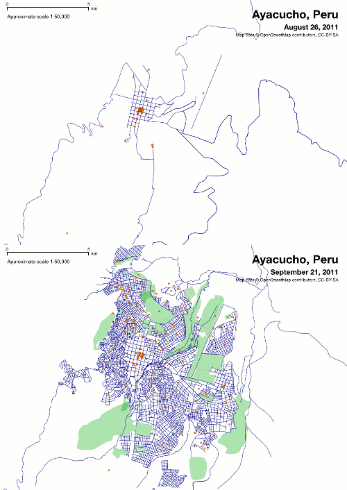
It was possible for us to make this map because the local government — the Municipality of Huamanga Province — had already opened up their street data, putting it into the global street database OpenStreetMap. Much of this work was led by Ruben Lopez, who is working as a dedicated open data apprentice for the Municipality and closely with our team as well. You can see from this before and after shot of the OpenStreetMap database that the city government’s data contribution is substantial.

Opening up basic street data on OpenStreetMap creates countless opportunities for releasing further data. Looking at just transit data, it’s now possible to assess city traffic, identify where traffic lights are needed, and simply show tourists how to get to the best local restaurants. New information can be cataloged, such as intersections with heavy pedestrian traffic, allowing city planners to better direct changes and new traffic and pedestrian signals.
We made the bus route map with the open source map design tool TileMill and are hosting it online with MapBox Hosting. If you’d like to play around with TileMill, you can download it here and find documentation and support at support.mapbox.com.
We’ll continue to work with the city government in Ayacucho and with Ruben to help guide their open data strategy and look forward to making more maps of it as its released. If you’re at Desarrollando América Latina this weekend, come talk to us about how we worked with the city government to open up data and mapped it with TileMill.
What we're doing.
Latest