The mapping platform for the the Pacific Rim Coordination Center (PRCC) that just launched at the APEC Leaders Meeting is designed to help communicate where disaster preparedness projects are currently taking place in the context of current and historical disasters. Ultimately better decision making happens when data and information are evaluated in the context of the situation, but getting all this information together remains complicated. PRCC’s goal is to create a decentralized network of public and private partners working together, with open information sharing serving as the primary coordination method.
Using open data and open standards is key for coordinating and decentralizing information between partners, as is bringing this information into a common operating picture like on the main PRCC site, data.pacificrimnetwork.org.

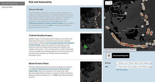
To help with information sharing the PRCC data site has a dedicated open data section — /open — where all data and maps used on the platform are available to access, use, and download. Data is available in multiple formats (shapefiles and CSVs). All maps can be embedded into any other website with just a few clicks (look how ReliefWeb embedded Thailand’s flooding vulnerability map). And the site’s open API allows full access to all the maps on the site.
The best way to see what is possible from the map’s API is to look at the main site: data.pacificrimnetwork.org, which is entirely built off the API. (We dogfood everything.)

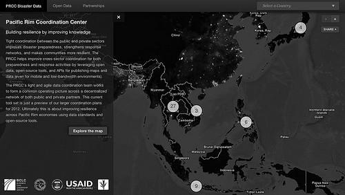
The PRCC platform visualizes data on three issues: disaster preparedness projects, the risk and vulnerability of specific countries, and 20 years of historical data of crises that have hit the region. This data is visualized through detailed country maps, with the three unique data sets served as different map layers. The initial map you see on the site is one of the entire region, showing where USAID and private sector disaster preparedness and relief projects are taking place and the amount of overall funding.
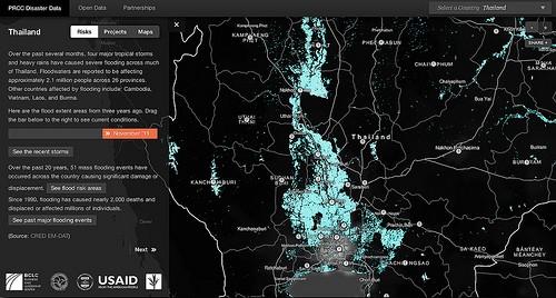
You can then drill down to look at the data on a country level, seeing a country’s risks and projects operating there, as well as the extent of a crisis over an extended time period. For example, the Thailand map below shows a time progression of the worsening floods in the region and what areas are most affected.

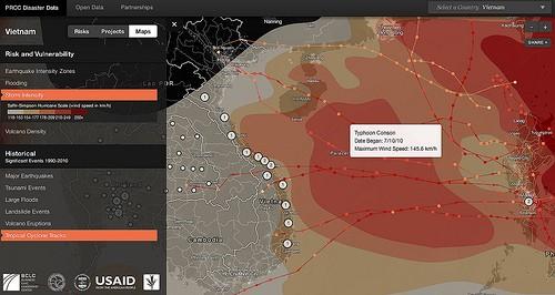
Vietnam is another good example of needing to overlay complex data sets to get a more comprehensive picture. The most frequently occurring disasters in the country are tropical storms and floods. As we focus in on Vietnam, you can see the estimated storm risk along the coast as well as browse where the most significant storms over the last 20 years have made landfall. Alongside the disaster data, you can view the project level information within the country to see where projects are operating in the context of past disasters. And you can view all risk and vulnerability data layers together in the maps tab to see a holistic view of the country’s overall disaster resiliency. This maps layer switcher allows any user to analyze disaster risk data for any country.

Technology
To match the goals of the PRCC, data.pacificrimnetwork.org is built entirely on open source tools. We designed the maps in TileMill, including using it to add interactivity to them. After downloading the data in multiple formats, we used QGIS and a PostGIS database to load the data into TileMill. Maps were rendered into the MBTiles file format. Using MapBox Hosting, we uploaded the maps and integrated them into the site with the MapBox Hosting API.
The website itself is just two HTML pages and JavaScript libraries. Everything besides the maps is hosted on GitHub Pages using Jekyll, similar to how we host this blog. Keeping the site lean with no CMS or database allowed us to create an incredibly fast browsing experience and ensure the data could be easily accessible in any bandwidth environment.
To see this in action check out data.pacificrimnetwork.org.
What we're doing.
Latest
