
This afternoon at 1:51 pm our office started shaking, pretty strongly. And then we all ran outside. Turns out a 5.8 earthquake hit Northern, VA, with its epicenter just northwest of Richmond, and we definitely felt it here in Washington, DC. After talking to the neighbors outside for a few minutes and of course checking twitter, we got down to work.
Using open data released almost immediately from the U.S. Geological Survey, Dave, Nate, and Matt mapped the earthquake using TileMill, our open source map design studio. This map shows the earthquake’s intensity of the earthquake at the epicenter, and then it’s strength as it moved out into the surrounding areas (including DC).
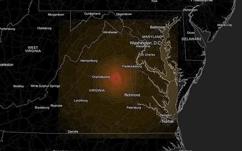
The earthquake layer is freely available and can be used with any map baselayer, and we encourage people writing about the earthquake to use this map online. You can also access this map here, and freely embed it in any site using the code below.
<div id='ts-embed-1314133504720-script'><script src='http://tiles.mapbox.com/mapbox/api/v1/embed.js?api=mm&size%5B%5D=500&size%5B%5D=500&center%5B%5D=-77.5360107421877&center%5B%5D=38.128075212115455&center%5B%5D=8&layers%5B%5D=world-black&layers%5B%5D=dhcole.na-roads&layers%5B%5D=dhcole.world-borders-light&layers%5B%5D=va-quake-aug&options%5B%5D=legend&options%5B%5D=zoompan&options%5B%5D=tooltips&options%5B%5D=zoomwheel&options%5B%5D=zoombox&options%5B%5D=attribution&el=ts-embed-1314133504720'></script></div>We also made a 3D map of the earthquake, testing out TileMill’s building symbolizer capabilities.
And below are views of the earthquake layer — with the same data — on two different base layers. These maps are available in MapBox’s TileStream map gallery, and can be embedded in any website just like a YouTube video.
Here’s the map in street view.
And here it is in satellite view.
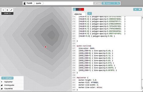
If you want to make your own map with TileMill, you can download the shapefile of the earthquake from USGS and use TileMill to style it however you’d like. Here’s a look at styling maps in TileMill.
If you have questions, just post them to support.mapbox.com.
What we're doing.
Latest