deck.gl-raster v0.10

This blog post was human written.
deck.gl-raster enables GPU-accelerated Cloud-Optimized GeoTIFF (COG) and Zarr visualization in deck.gl. This release brings faster COG loading, new examples, and a new API to share data sources across layers.
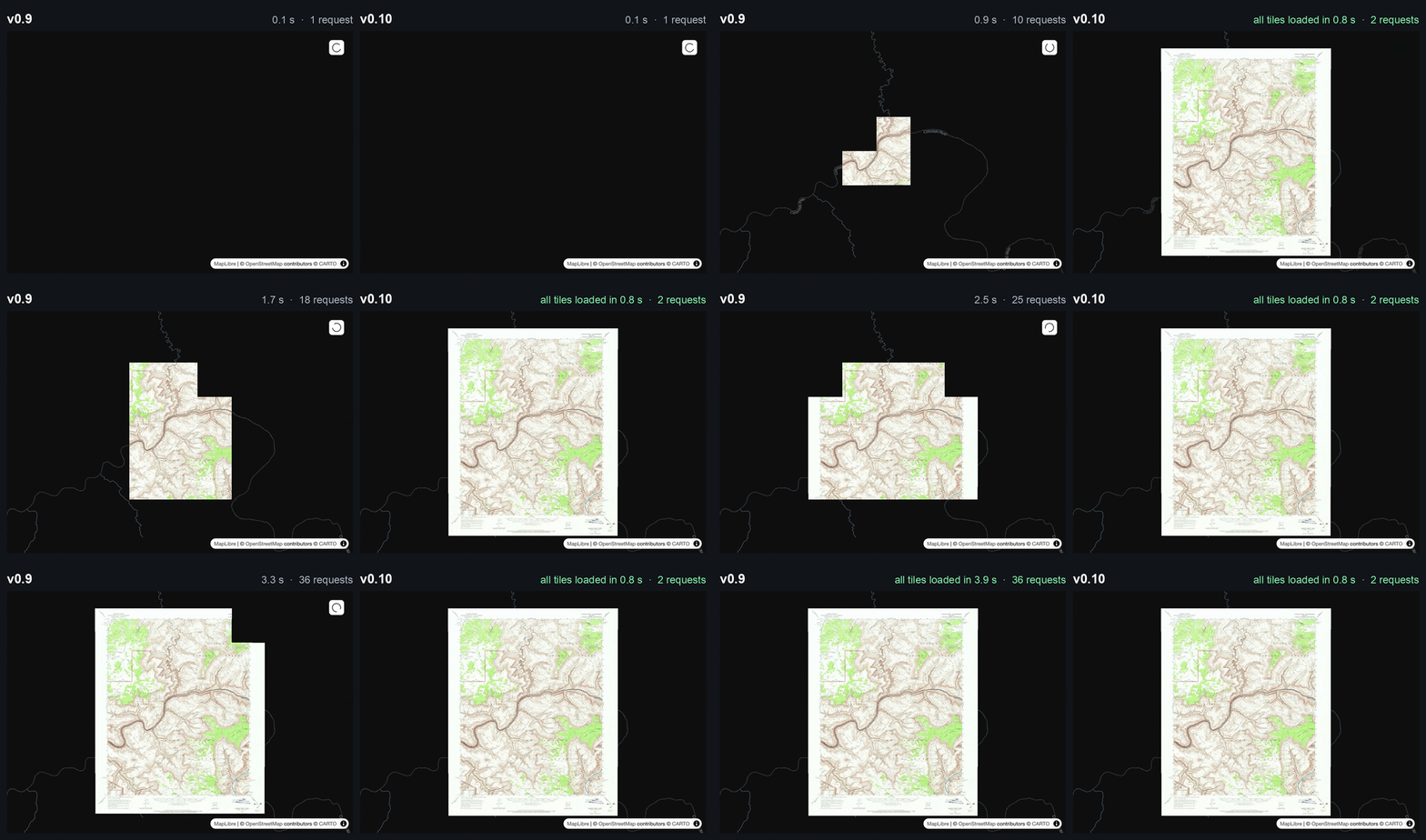
COG tile range request coalescing
The COGLayer now merges and combines neighboring tile requests automatically. We see up to 4x faster loading in the USGS topographic map example:
This is possible because client-side rendering has more information about a file's underlying byte layout than a comparable server-side rendering approach would have.
In the prior server-side rendering approach: if you have 8 COG tiles on screen, you'd need to send out 8 standalone requests, one for each tile. The client code has no way to optimize this, because only the tile server knows that the byte ranges for these tiles are actually close together in the COG file.

Sending out parallel requests like this isn't always a bad idea, but it's particularly bad over HTTP/1.1, where Chrome allows a maximum of six current requests at a time to the same origin. Since many object storage buckets (especially AWS S3) only support serving HTTP requests over HTTP/1.1, it's especially important to reduce the total number of concurrent requests. This makes the biggest difference when those requests are small.
Compare to our new client-side rendering approach: since we have the full metadata of the COG in the client, we know that among those 8 tiles, they group into two adjacent runs of bytes. Therefore, we can make just two requests to cover the entire image.
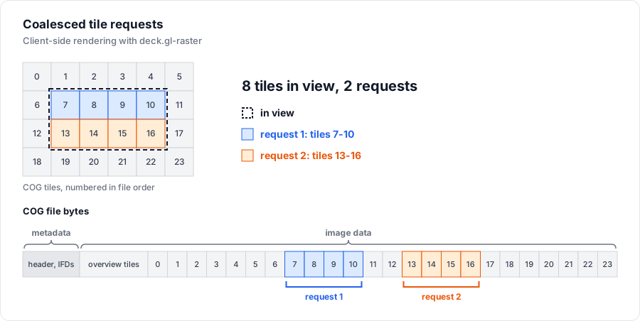
Then within each of these merged request ranges, we make use of the streaming request. As soon as the stream has finished loading content for the first tile, we start decoding the image bytes for that tile. This helps to maintain fast latency rather than waiting for the entire coalesced request to finish before rendering anything.
Note that the USGS historical topographic data source is particularly sped-up by COG tile merging because its tiles are only 128x128 pixels. The smaller the tile size, the larger the gains from coalescing.
We plan to also implement range coalescing for sharded Zarr datasets in a future release.
New examples
Mapterhorn PMTiles Terrain render
We have a new example loading from the Mapterhorn global PMTiles dataset.
PMTiles is a cloud-native archive format for tiled data. While PMTiles is often used for vector tiles, it can be used for raster data as well, which pairs well with our client-side rendering approach.
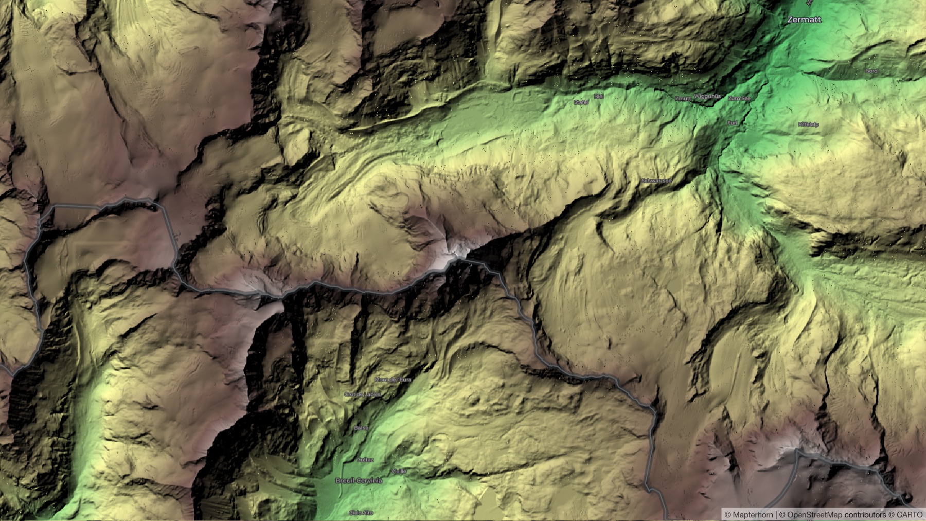
In the future we could create a helper layer for using PMTiles.
GDAL VRT Mosaic
We have a MosaicLayer in deck.gl for rendering a collection of independent images. A new demo shows how to load a GDAL VRT and render each of the COGs in view.
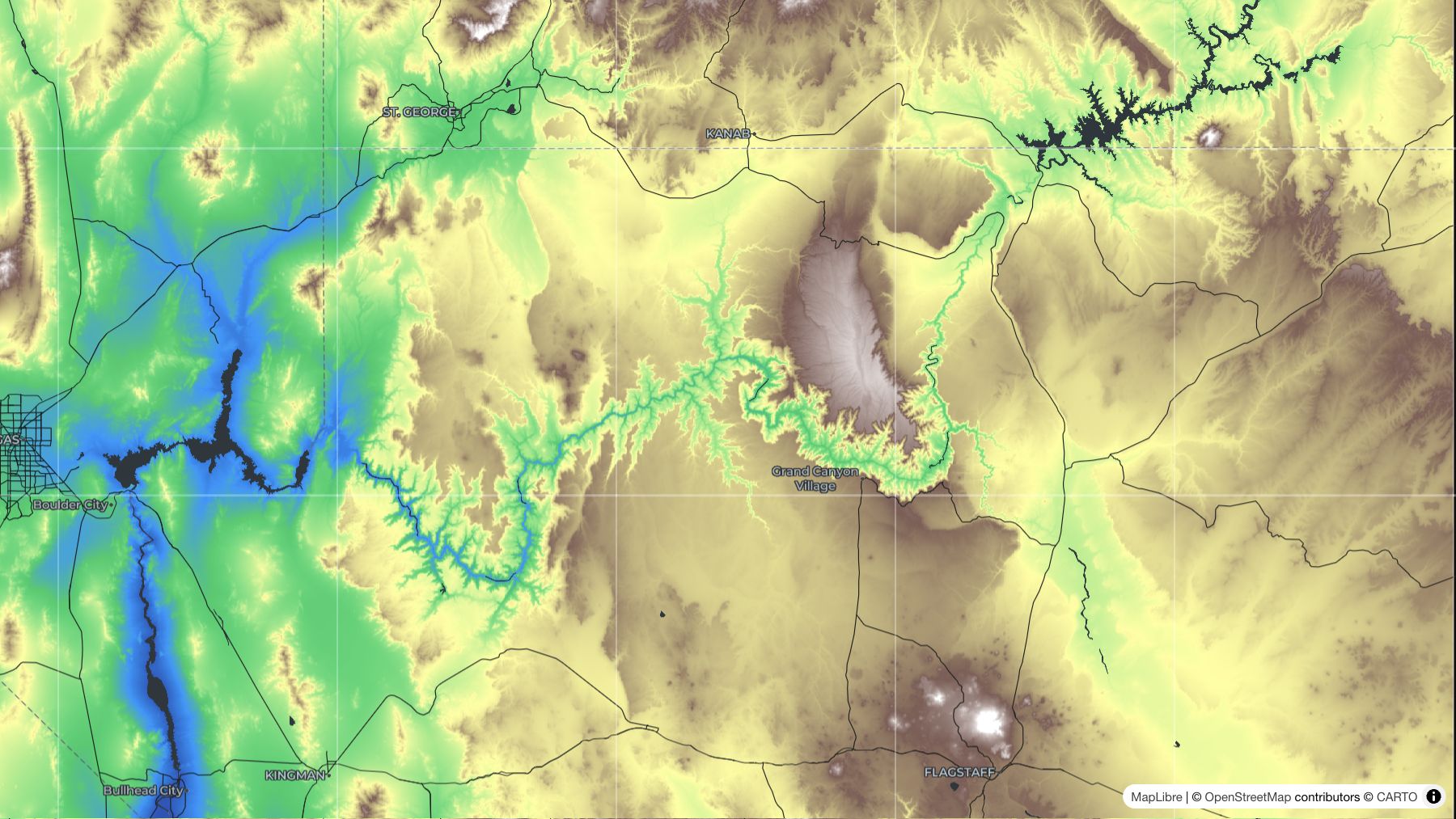
We also export a new parseVRT helper to parse a GDAL VRT XML file as mosaic items (#835).
Zarr globe rendering
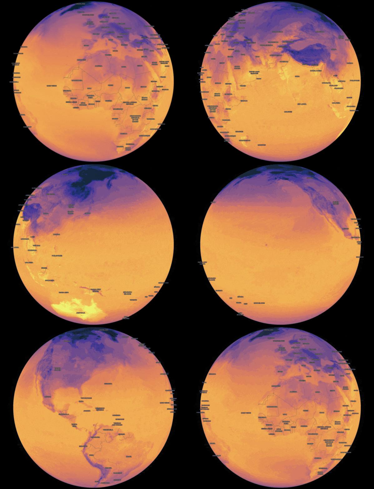
We have a new example of rendering Zarr data on a globe.
New "Sources" API to share data across layers
We have a new API to let you open up a reference once and use it across multiple layers. The COGSource, MultiCOGSource, ZarrSource classes cache the metadata of a give data source so that separate layers don't have to re-open and re-parse the same underlying metadata.
In the future, we'll also implement data caching so that multiple layers can render from the same inputs without downloading twice.
MosaicLayer
Mosaic items that are outside the current view keep their source cached to avoid re-fetching item metadata, but drop any deck.gl layers and thus free any GPU memory (#839). This helps to significantly reduce GPU memory pressure for large mosaic renders.
Zarr
The new ZarrSource applies relevant GeoZarr metadata from a Zarr Group onto the child Array (#838).
Reliability
We've fixed several memory leaks, see #786 and #834.
We've also fixed tile traversal, especially for rotated COGs, where the lower-resolution parent tile was being incorrectly picked (#841).
Upgrade notes
The upgrade notes section was written by an LLM (Claude Code).
Every layer now takes its data as source: either a source you opened, or the input for the layer to open one from, such as a URL or a Zarr store. TypeScript flags the removed props below. JavaScript ignores them without a warning, so a layer that still gets only its old props draws nothing.
COGLayer
geotiffis nowsource, and takes the same inputs (#799).onGeoTIFFLoadis nowonSourceLoad, which gets the openedCOGSource. Itsgeotiff,projectionandgeographicBoundshold whatonGeoTIFFLoadused to receive. It's called only when the layer opens the source itself.epsgResolverandconcurrencyLimiterare now options ofCOGSource.open.COGLayerandMultiCOGLayernow default tomaxRequests: 256anddebounceTime: 50, so the tiles in view reach the range reader together. A per-origin limiter, six requests at a time, caps the requests instead (#809).
// 0.9
new COGLayer({
  geotiff: url,
  onGeoTIFFLoad: (geotiff, { geographicBounds }) => fit(geographicBounds),
});

// 0.10
new COGLayer({
  source: url,
  onSourceLoad: (source) => fit(source.geographicBounds),
});

// 0.10, with options
const source = await COGSource.open(url, { epsgResolver });
new COGLayer({ source });
MultiCOGLayer
sourcesis nowsource, without the{ url }wrapper, andMultiCOGSourceConfigis removed (#801).onGeoTIFFLoadis nowonSourceLoad, which gets the openedMultiCOGSource. Itsgeotiffs,geographicBoundsandmultiTilesetDescriptor.primaryKeyhold whatonGeoTIFFLoadused to receive.epsgResolverandconcurrencyLimiterare now options ofMultiCOGSource.open.- Files that don't share a CRS and an extent are now rejected. 0.9 drew them all in the first file's CRS.
// 0.9
new MultiCOGLayer({ sources: { red: { url: redUrl }, nir: { url: nirUrl } } });

// 0.10
new MultiCOGLayer({ source: { red: redUrl, nir: nirUrl } });
MosaicLayer
sourcesis nowdata, and theMosaicSourcetype is nowMosaicItem(#804).- The callbacks get the item first and the opened source as
source, where they used to getdata.renderSourceno longer gets asignal(#821), and it now getssubLayerPropsto spread onto the layer it returns (#789). onViewportLoad's entries are now{ item, source }instead of{ source, data }, soentry.sourceis now the opened source rather than the item. WithSourceTleft at its default ofany, TypeScript doesn't catch code that still reads it as the item, so check everyonViewportLoad,onSourceLoadandonSourceUnload.maxCacheByteSizeis removed (#843).maxCacheSizestill sets how many items keep their opened source. To bound memory by bytes, setmaxCacheByteSizeon the layer thatrenderSourcereturns.- Items out of view now drop their layers and GPU memory, and keep only their opened source (#839).
// 0.9
new MosaicLayer({
  sources: items,
  getSource: (item, { signal, concurrencyLimiter }) =>
    GeoTIFF.fromUrl(item.url, { signal, concurrencyLimiter }),
  renderSource: (item, { data, signal }) =>
    new COGLayer({ id: item.url, geotiff: data, signal }),
});

// 0.10
new MosaicLayer({
  data: items,
  getSource: (item, options) => COGSource.open(item.url, options),
  renderSource: (item, { source, subLayerProps }) =>
    new COGLayer({ ...subLayerProps, source }),
});
ZarrLayer
node,variable,metadataandepsgResolverare removed (#812). Pass a zarrita store, or an opened group or array, assource. For options, open aZarrSourcefirst:pathreplacesvariable,geoZarrMetadatareplacesmetadata, andepsgResolvermoves there too (#838).ZarrLayer<Store, Dtype, DataT>is nowZarrLayer<DataT, Dtype>, andZarrLayerPropschanges the same way.ZarrSource.openreturns a generalZarrSource: narrow its data type withsource.is("float32").- A change to
selectionnow fetches tiles again (#818), so apps that put the selection in the layer'sidto force a reload can drop it. - An array now inherits its group's
proj:andspatial:attributes (#838).spatial:dimensionsis read by position, Y then X, as v0.1 of the spatial convention says (#785). Multiscales levels are sorted finest first by pixel size (#851).
// 0.9
new ZarrLayer({
  node: group,
  variable: "temperature",
  metadata: attrs,
  selection,
  getTileData,
  renderTile,
});

// 0.10
const source = await ZarrSource.open(store, {
  path: "temperature",
  geoZarrMetadata: attrs,
});
new ZarrLayer({ source, selection, getTileData, renderTile });
@developmentseed/geotiff
GeoTIFF.fromUrlno longer takeschunkSizeorcacheSize(#807). They're now options of aRangeReader,minMetadataReadBytesandcache.metadataBytes, which you pass tofromUrlasreader.